Canyon Creek Battlefield
In September 1877, the nimíipuu made a stand at Canyon Creek to slow the pursuing U.S. Cavalry. Their courage at this high prairie battlefield bought time for the people to continue their desperate journey toward freedom.
Getting There
The Canyon Creek Battlefield interpretive site is located on Buffalo Trail Road, about 8 miles north of Laurel, Montana. From I-90 at Laurel, take exit 434 and head west on Highway 80. Turn north onto South 1st Avenue and continue for 2 miles until you reach Buffalo Trail Road. Follow Buffalo Trail Road north for about 6 miles, then turn right onto Lipp Road. The site is on the left.
Nearby airports include Billings-Logan International (16 miles east) and Bozeman-Yellowstone International (145 miles west). Public transportation is limited in this area.
What You'll See
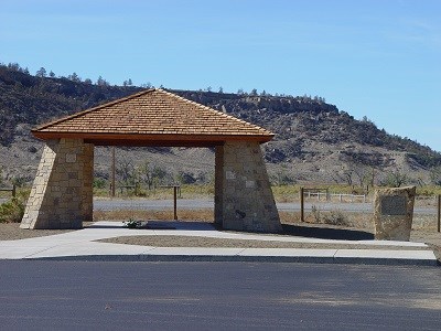
The site sits on private and state-owned land, mostly unchanged since the battle. Today you'll find a covered pavilion, a stone monument, and several interpretive panels that explain what happened on September 13, 1877. The undulating grassland and sagebrush-covered ridges look much as they did 150 years ago, giving the place a quiet power.
Please respect the landowners' property rights and view the site from the roadside pullout. The battlefield itself is not open for walking.
Laurel, Montana has a Chamber of Commerce visitor center with a statue of Chief Joseph. The Big Hole National Battlefield visitor center is about 300 miles east and has additional information about the Nez Perce Flight of 1877.