Visit Cottonwood Skirmish Site
After crossing the Salmon River twice and emerging onto the Camas Prairie, the band of nimíipuu engaged the U.S. Army in a series of skirmishes near Cottonwood, Idaho from July 3rd to 5th, 1877. A historical marker at a highway pullout preserves this story.
Getting There
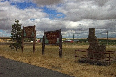
A historical marker with information about the Cottonwood Skirmish Site is located off U.S. Highway 95, approximately 2 miles south of Cottonwood, Idaho. The site is on private property and is not publicly accessible.
From Cottonwood, continue south on U.S. Highway 95 for 1.5 miles. The highway pullout will be on your left at mile marker 253. Stop at the pullout to read the interpretive markers.
What You'll See
Two historical markers at the highway pullout provide detailed information about the Cottonwood Skirmish. They explain the battles that took place July 3rd-5th and their significance in the Flight of 1877. The actual battle site lies on private property, but the pullout offers a good vantage point for understanding this chapter of the story.
Understanding These Battles
The Cottonwood Skirmishes represented a crucial phase of the Flight. After defeating the U.S. Army at White Bird Canyon and maneuvering across difficult terrain, the band continued to hold off pursuing forces. These engagements tested the stamina and resolve of both the nimíipuu warriors and the Army units pursuing them.